Wednesday, November 28, 2012

Robson Square vs. The Robson 5: Fruitful Debate or False Dichotomy?


Vancouver's planning circles and concerned citizens have been abuzz with news over the proposed reopening of Robson Street between Howe and Hornby to automobiles and buses. Peter Marriott has done a fantastic series of articles on Gordon Price's blog on the importance of leaving Robson Street open to the #5 Robson route. In short, the main problem with the Robson Street closure was that because of detours, the #5 Robson lost crucial connectivity with the rest of the city west of Robson Square.

So since Peter's done all the work of explaining the reasons, I'd just like to tack on a couple of my own observations:


(c) HCMA

1. Normally I visit the West End every now and then, 

to get delicious, delicious ramen at Kintaro or Santouka (Denman @ Robson). Since the rerouting of the #5, I haven't visited the West End at all, because it now takes about 10 extra minutes to get there (at least when coming from areas south of FC). While that might not seem like a whole lot of time, I would imagine it would quickly add up for a resident of the West End: an extra 20 minutes a day is an extra 100 minutes of commuting a week. The 5 Robson also happens to be a particularly high ridership line, so the aggregate amount of time wasted is substantial.

2. The grounds for a transit vs. pedestrian debate are tenuous. 

Examples from around the world show that it IS possible to have transit and pedestrians in the same space. What's more, it's also possible to have buses and pedestrians in the same public space. Andrew Jones demonstrates some excellent examples of light rail and streetcars that cruise through public spaces. Here are a couple of public squares where buses are allowed or given exclusive access:

The Baldachin (great glass roof) in Bern, Switzerland, houses a public square and combination bus/light rail interchange. The S-bahn/intercity train station is located underneath, so there is always tons of activity and movement, even though the city of Bern itself isn't even half as populous as Vancouver. (pop: 125 000)


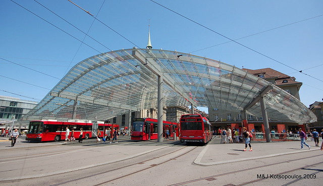
(c) Mel and John Kots. Flickr

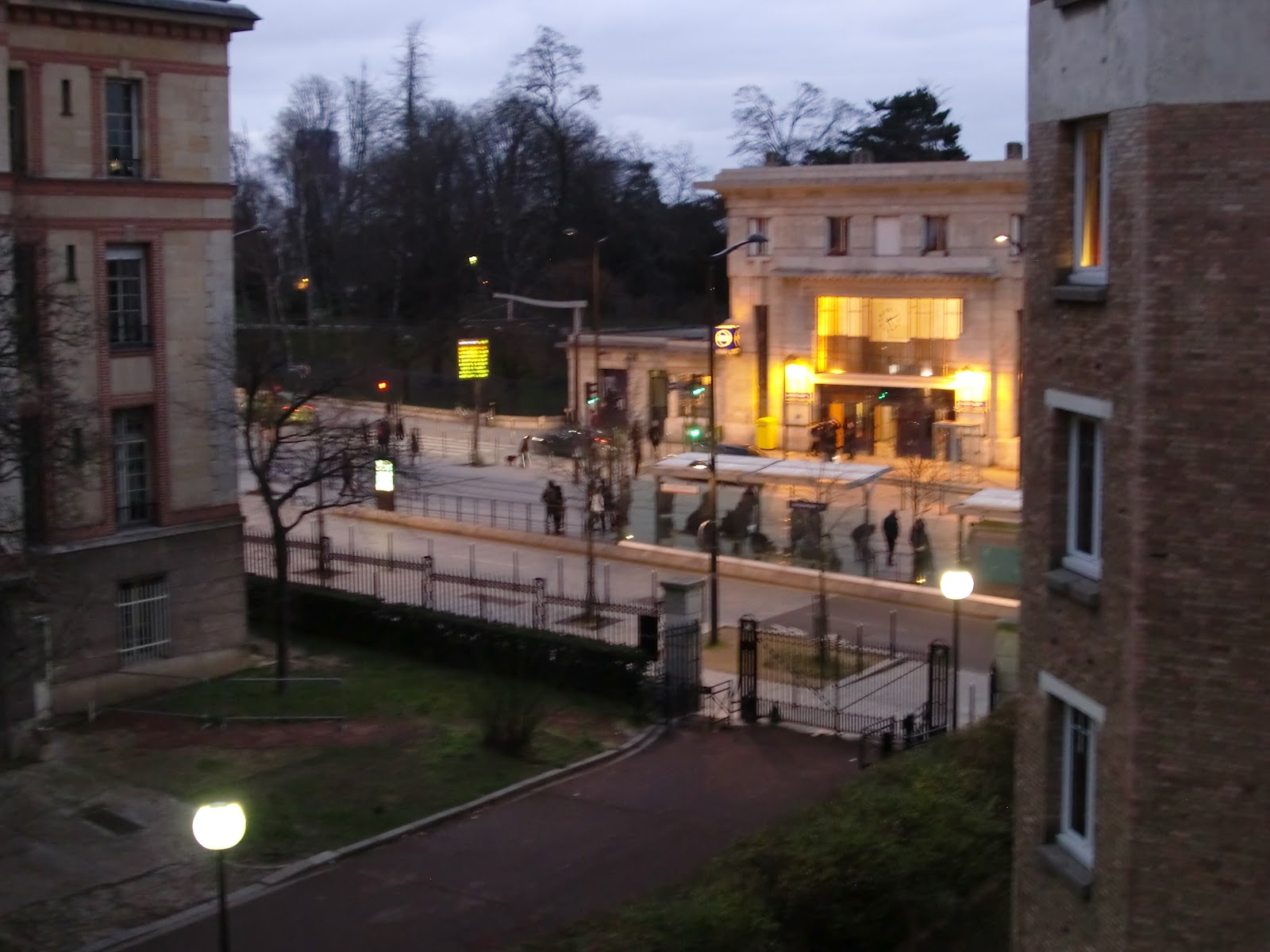
And my favourite is a little plaza in Paris you've probably never heard of (yes, I did just say that!). I'm not even sure if it has a name. Tucked immediately beside St.-Paul station on Ligne 1 is a trapezoidal sliver that works perfectly in its role as a public space: a narrow, slanting public square to mimic the narrow, crooked streets of Le Marais. Even though it's tiny, only buses and delivery trucks are allowed though. Other vehicles need to reroute.


(c) Google Maps, edits by me

Buses move slowly through the square, but it's a lot faster than making the long detour:
but no cars allowed through! (c) Google Street View

Metro riders spill out into the space and create a lively atmosphere whenever the time, whatever the season. The bus exclusive lane is on the left; Rue de Rivoli is on the right. There's even room for a carousel (the covered yurt in the back):

\
Just a few examples of some of the creative planning that's been done around the world to accommodate public spaces and effective transit. 


Saturday, June 16, 2012

Could truck-exclusive lanes help transit?

I used to be against the idea of the Gateway Program altogether, but now that it's in construction, I can only offer suggestions to make its use as efficient as possible.

One of the main reasons for the Gateway Program is to help facilitate the movement of goods from the interior to the ports: specifically, to help trucks quickly get from the far end of the Valley to the coast, either at Metro Vancouver, North Vancouver, Tsawassen, or the Roberts Superport.


While trucks might see slightly better congestion management immediately, the sad fact of the matter is that in five years' time, the trucks are going to be battling the same level of congestion on major routes throughout the region, leading to the same delays in freight traffic and the same losses that have been worrying the BC Ministry of Transportation this whole time. Automobile Traffic fills most of the space it is given, unless careful mitigation of land use or travel restrictions is involved, or the city spends ridiculous amounts of money continually expanding the network. (Houston has been able to decrease congestion relative to other American cities while spending $1 billion per year for 15 years. That's 5 Gateway Programs, or 15 South Fraser Perimeter Roads over 15 years, or enough transit to put every city in Metro Van on Skytrain, [or build out an amazing regional rail system to Hope (via the interurban), run medium-speed trains to Whistler (75 minute travel time), and fund the rehabilitation of the passenger railway corridor to the US border to accommodate 300 km/h High Speed Rail to Seattle]. However, the $15 billion price tag doesn't nearly account for the environmental and social effects of the induced sprawl.)

From the above study:


"The problems people associate with roads - congestion, air pollution, and the like - are not the fault of  road investments per se. These problems stem mainly from the unborne externalities from the use of roads, new and old alike..."

So why not mitigate the new roads - North Fraser Perimeter Road, South Fraser Perimeter Road, and Highway 1 improvements - by effective tolling and/or truck-only lanes? The relative importance of a truck full of time-sensitive shipments is much higher than that of one average commuter (or three to four, if you want to define it by the size of a truck) - so why don't we let the trucks have priority? This would ensure long-term usability of the new roads specifically for the freight sector, which needs the Gateway Project the most.

The "plight" of car commuters, however, will only be eased with strict land development regulations along the corridor, a new strong regional transit network that provides a viable and useful alternative to the current automobile-exclusive infrastructure, and perhaps a tolling system which will allow the people who need to commute by car the most (highest willingness-to-pay) to have access to swift-moving, decongested roads? The two developments (tolling the highways and improving transit) need to happen at the same rate and at the same time. Tolls shouldn't be raised if transit is not improved at the exact same time. Funding scheme for Translink, anyone? Anyone?

The idea of separating trucks and cars has been supported in depth by these folks and these folks too.  Take a look.


Friday, June 15, 2012

Cute: Super Mario Skytrain Map

Dave Delisle from Dave's Geeky Ideas has this awesome Super Mario Bros. 3-esque rendition of the Skytrain System in Vancouver. Cute and a little nostalgic for anyone who grew up playing Nintendo.


Thursday, June 7, 2012

4th and King (Caltrain Railyards) Proposal

As part of an urban design studio at Stanford (URBANST171), I created an urban development plan for the Caltrain Railyards that currently sit South of downtown San Francisco. Future plans call for I-280 to be converted into a ground-level boulevard at 24th St. in Potrero Hill and Caltrain to be buried underground in the same tunnel as California High Speed Rail, leaving an enormous plot of land available for development. Caltrain hopes to move the 22nd st. station to the intersection of 16th st. and 7th, and bury the station at 4th and King underground, along with the possible High Speed Rail station too. HSR and Caltrain would then continue up to the Transbay Terminal just off of Market St.

As part of my proposal I concentrated on the transportation connectivity of the site to the rest of SF, something that has been lacking in recent years. 

Some more images from the proposal:


Here's the entire presentation, somewhat successfully imported into Prezi. Contact me if you'd like the original ppt, which is a bit more coordinated in terms of fonts and color schemes.

Many thanks to Danno Glanz of Calthorpe Associates, an amazing teacher and mentor.

Jarrett Walker in SF!

Last night I attended Jarrett Walker's enlightening presentation at the SPUR headquarters in San Francisco. (654 Mission St.) Themes he stressed were:

1. The core mission of transit as abundant access without personal vehicles over distances too far to walk - thinking of transit as a multiplier of walking. For this reason, he advocates for the placement of all transit stops (including bus stops) at least 1/4 mile or even 1/2 mile apart. Any inter-stop distance of less a 1/4 mile hampers the overall speed of transit while simultaneously competing with walking.

2. The five main qualities of transit service, which are:
A. Frequency
B. Span (operating hours)
C. Speed
D. Reliability
E. Capacity

Frequency and Capacity are largely technology-applicable. Frequency is very hard to describe to a motorist - there is no perfect analogy. Speed and Reliability are largely reliant on stop frequency, stop delays, and the amount of things getting in the way.

Frequency is the hardest thing to preserve - budget cuts will target frequency before all else.

3. "Listen to our tools" - deal with the choices presented by materials. The analogy is that one cannot grow a banana tree in Portland because the materials - the climate, the soil, the humidity, (the pollinators?) do not exist.

4. Moving from Symbolic or ultra-specialized transit (unsustainable and unefficient models that enforce a unimodal way of thinking about transportation) to transit that is designed for the majority of the population

5. Jarrett's regular themes: Be on the Way, the Potential of the Suburban Blvd. (in its transportation form, not in its zoning or architectural form)

An interesting question was brought up about Jarrett's thoughts on the 26-odd transit agencies, each with different fares and schedules, that make up the Bay Area. Jarrett said that he's ambivalent on merging systems. He doesn't mind that local communities take care of their own local systems, which makes administrative sense, but he did lean toward more integration on the regional level - he stated that Caltrain is "the perfect" opportunity to create a successful regional link but it's wasted because 1. Peninsula communities are too afraid of development and 2. frequencies are far too low and 3. Silicon Valley corporations don't take proximity to Caltrain into consideration when siting their campuses (e.g. Facebook. ugh.) One wonders how huge an impact Caltrain could make if it were funded to run 15-minute frequencies during the day (around the threshold for "frequent transit").

Overall, a great thought-provoking presentation and I'll post some of my own thoughts in a bit.

Wednesday, March 7, 2012

Burnaby Mountain Ski Resort (kidding, but not really)

In response to this article which has scrapped plans for a gondola to Simon Fraser, at least in the near future, I offer up a proposal to cover the $12m budget gap: make the side of Burnaby Mountain into a student-run ski hill on snowy days.
That should explain it.

Saturday, February 25, 2012

Paris's High Line

This is a picture of the real High Line in New York:
Courtesy of metropolismag.com

Actually, the famous landmark in New York that has been making urban designers and city folks around the world ooh and aah should more rightly be attributed to the Paris Promenade Plantée, which sits upon the Viaduc des Arts. And in fact, I would say that Paris's older version is better.


While that might seem like a crude, sweeping judgment, my case lies not in what lies in plain view, but rather in what lies underneath. Part of the re-imagining of the Paris Viaduc des Arts was to create a space underneath the park that could be used for commercial and community purposes.
Underneath the arches of the old train tracks, the spaces were transformed into ateliers and viable commercial spaces. This kind of innovation (reusing old structures for new purposes) is seen all throughout Paris and Europe: many an old factory or warehouse has been turned into a museum or an institute, and the old Haussman apartments from the 1800s are still in good use today, with interiors that are fully updated to modern standards. Instead of automatically tearing down old buildings, Europeans tend to also consider re-using what still works. Of course, Europeans also tend to build buildings for longer than 30 year life spans. (ehhhem.)

Sometimes the constraints which seem to impede actually let creativity flourish. In Europe and Asia, due to the lack of space, designers have come up with all sorts of ways to make the most of it. The key: efficiency and multifunctionality.

A view from the Promenade: the apartments on either side date back to the 1800s. Notice the little church squeezed in too!
Now let's go back to New York. What's underneath the High Line?
Courtesy Google

Concrete paving, fenced off areas, and dark corners. That's also a lot of wasted space. Now I know that the High Line actually goes over and through a number of different buildings, but there are still a lot of dull, underutilised areas underneath the structure. Put something there! Make it a part of the High Line experience! Put a commercial pedestrian street, or a lighted bike route, or make it a plaza for local markets (again an idea from Paris: will talk about it in the future), or make it a skate park, or put affordable housing! But just do something. You might say that the constraints are too difficult, that nothing will be cost-effective underneath; forget that thinking. Europeans (and Asians) have been dealing with much worse constraints and have come up with some of the most creative ideas for re-use that have been cost effective, socially equitable, and sustainable.

We've already got the 'high' of the High Line, with the pretty park and the views of the skyline, but now we need the 'line' of the High Line: the lines that connect the park with the community. No crimes have been reported yet on top of the viaducts, but what about underneath? The attention is being well paid to the surface of the high line, but underneath the structure tells a different story of neglect and inattention to a project's context within the community. The High Line misses out on what the Promenade Plantée does so well: The Promenade is not just a place of respite and a location in itself, but it also connects itself to street level and the life there.


That's why the Promenade Plantée is better.


Super-Marmite and Life-share-renting


Super-Marmite.com is a French startup (yes they exist!) with a really cool idea for gastronomically-influenced yet budget-minded people like me. It’s a website where you can sell portions of your own cooking with other people or buy portions of other people’s meals. It’s mostly in French as of now, but from the looks of it, English translation is underway.

Economically, this is genius. If you’re already cooking, the marginal cost of making an extra portion is really quite low - in terms of money, but also in terms of time and effects on the environment. Why not have people pay you to piggyback off of your fixed costs and compensate you at rates that are mutually beneficial? (i.e. cheaper than going out to eat for the consumer but enough to pay back the cost of the meal + a bit of profit for the cooker)

From an urbanist perspective Super-Marmite.com is exploring another facet of this new life-share-renting phenomenon which is almost socialist in its philosophy yet capitalist in its methodology. People are realizing that if they open up their lives a bit and share (read: rent) out a place in their house (Airbnb) or a place in their car (Zimride) which would be underutilised anyway, they can:
 
a) make a profit;
b) get to know people and make new friends!

From the consumer perspective, one also gets the double benefit of:

a) acquiring services or goods at or below the market cost;
b) getting to know people and make new friends!

Arguably b) is the more important thing in both cases, but often a) can be a powerful motivating factor to get people to join or subscribe. I haven’t used super-marmite.com yet (the prospect of having to converse with people completely in French for any extended period of time scares me a bit) but I will try it out this week! Let me know if you’ve had any experiences with Super-marmite, Zimride, or Airbnb and what you think about these new developments in social network realization.

First Post!

Welcome to my academic/professional blog on urbanism! My full name is Theodore Lim, but you can call me Theo. I grew up in the beautiful city of Vancouver, Canada (which will forever be my home), but for the past 2.5 years I’ve been studying Civil Engineering at Stanford University in California. At the current moment I am abroad in Paris, France, but I’ll be back on campus in April 2012.


I’ll start this off with an analysis of the interesting street life just in front of my building. Here's a view out my window: the facade across the building is the RER Line B stop Cité Universitare. In the middle of the street is the tramway (Line T3) stop of the same name. In spite of the fact that there is virtually no commercial life directly near the station, this place is always filled with people, most of whom are transferring from the N-S RER line to the E-W Tramway line.


Cité Universitaire is along the southern side of the city and is a quarter dedicated exclusively to student housing. Look for the RER line B (thick vertical blue line); trace it from the bottom of the map till it intersects with the thin orange line in the bottom quarter of the map.  The Cité consists of over 30 maisons representing different parts of France and different countries around the world. However, there is basically no commercial activity in the area, except for the cafeteria, bakery, and theatre in the Cité Internationale main building, located about 100 m south of the Tramway stop. North of the stop is Parc Montsouris, a large park which is popular with joggers and families which has a gentle slope upward toward the station.
Most of the pedestrians who use Cité Universitaire transfer to the Tramway from the RER or Vice Versa. The RER itself is actually much faster than the Métro, as it has fewer stops and runs with higher speed trains. Such is the case that people will take the tramway from Jean Moulin or Porte De Choisy to Cité Universitaire to take the RER because it’s that much of a time saver.
Because of the high numbers of rushed pedestrians, it’s interesting to see what the planners have done with the intersection.


Point 1: Placement of traffic lights
Now this is actually something seen all over Paris. The traffic lights here are not strung up high over the traffic; no, all the traffic lights sit about 3 m (10 ft) above the ground directly on lampposts. There’s also a mini traffic light lower down on the post, which specifically caters to the first motorist in the lineup (who can’t see the traffic light above) as well as to any bicyclists. This entire traffic light setup is meant to keep motorists looking down at the road ahead, where people are likely crossing.
Point 2: Distribution of Traffic Lights
Notice that there are not just one set of traffic lights in front, but actually two more sets down the road. About every 30 seconds, or whenever a tram arrives, all the lights turn red at once. Any cars stuck in the ‘middle’ of the intersection are forced to stop instead of carrying on their way. In this way, traffic on the entire street stops, allowing pedestrians to cross. It doesn’t matter if there are cars in the way because pedestrians can easily thread their way through the breaks. What’s important is that all traffic has stopped, and then the entire length of street from the first traffic light to past the last traffic light essentially becomes one long pedestrian crosswalk.
Point 3: Textured Driving Surface
Not only at the crosswalk, but also about 20 m before and 20 m after, there is a cobblestone texture on the road instead of asphalt. Essentially this indicates that ‘there might be pedestrians crossing here anyway’ and, in a sense, appropriates the right-of-way to the pedestrian. There’s something subconscious and powerful about the rumble of driving over cobblestone streets that tells drivers to slow down and cede pedestrians the right of way.


Point 4: The Grassy Median
Pedestrians (such as myself) will often cross using the grassy median. This is generally not a problem or a hazard to the trams, since they tend to run at slower speeds and can stop about as fast as a car can. (Still, you need to be extra careful when crossing any set of train tracks!) Instead of fencing off the tracks, filling in the tracks with grass is not only pretty, but allows the pedestrian more freedom to cross the street at will and breaks down the barrier usually created by train tracks.
Point 5: Bicycle Signalling
The bicycle lane merges with the road near the station as the rights of way are not wide enough and a bicycle lane cutting through the pedestrian crosswalk could be dangerous. So instead, the bicyclist is asked to merge with traffic, taking advantage of the frequent red light cycle to give the cyclists priority to merge without being afraid of getting sideswiped. See in the first picture that the bicycle light (middle right) is red while the auto light is green; when the auto light is red, then the bike light turns green so that cyclists can merge into the road without problems. The cyclists are asked to stop with the auto traffic to give pedestrians the right of way; although cyclists often just continue through without stopping, the merge with auto traffic causes them to slow down and be more careful when crossing through the pedestrian crosswalk.
Point 6: It’s intuitive
The best part is that the entire intersection is intuitive. Each person or user of transport is given only one thing to watch for, or one area to watch at a time. The drivers watch the lights, which are positioned low down to make pedestrians visible. The pedestrians watch for cars at the road, then after the island, they are warned by large tram crossing lights if a tram is coming (or one could just look down the tracks - there are no obstructions). Bicyclists don’t have to worry about getting clipped, so they can themselves prevent collisions with pedestrians.
And… that’s about all I’ve got to say about design. The intersection works - well, I might add.